
Egremont, AB Weather

04:00 Wednesday
Snow
Snow with cloudy skies
-2° Feels like -8°
90% 0.012 in
reloj Hourly Snow expected in the next few hours
  • Today 28 Oct. Snow with cloudy skies 90% 2.76 in 1° / -3° Moderate north wind 19 - 35 km/h
  • Tomorrow 29 Oct. Snow with partly cloudy skies 80% 0.59 in -2° / -7° Moderate northwest wind 12 - 20 km/h
  • Friday 30 Oct. Scattered clouds 0° / -10° Gentle southeast wind 10 - 17 km/h
  • Saturday 31 Oct. Partly cloudy -1° / -8° Gentle south wind 7 - 13 km/h
  • Sunday 1 Nov. Partly cloudy 0° / -6° Gentle west wind 12 - 19 km/h
  • Monday 2 Nov. Scattered clouds 3° / -4° Moderate west wind 14 - 26 km/h
  • Tuesday 3 Nov. Clear 5° / -2° Strong northwest wind 26 - 58 km/h

Weather Forecast for Egremont, AB Today

, 28 October

Tomorrow

, 29 October
05:00 Snow with cloudy skies 90% 0.12 in -2° Snow
Feels Like -8°
Moderate north wind North 19 - 34 km/h
UV Index 0 Low SPF: no
  • Snow Snow 90% 0.12 in
  • Humidity Humidity 92%
  • Dew Point Dew Point -3 °C
  • Clouds Clouds 100%
  • Snow depth Snow depth 1.57 in
  • Feels Like Feels Like -8 °C
  • Wind Wind - Average 19 km/h
  • Pressure Pressure 1015 hPa
  • Snowline Snowline 1312 ft
  • Fog Fog No
  • Wind - Gusts Wind - Gusts 34 km/h
  • Visibility Visibility 6 km
06:00 Snow with cloudy skies 90% 0.12 in -2° Snow
Feels Like -8°
Moderate north wind North 19 - 34 km/h
UV Index 0 Low SPF: no
  • Snow Snow 90% 0.12 in
  • Humidity Humidity 91%
  • Dew Point Dew Point -3 °C
  • Clouds Clouds 100%
  • Snow depth Snow depth 1.57 in
  • Feels Like Feels Like -8 °C
  • Wind Wind - Average 19 km/h
  • Pressure Pressure 1016 hPa
  • Snowline Snowline 984 ft
  • Fog Fog No
  • Wind - Gusts Wind - Gusts 34 km/h
  • Visibility Visibility 6 km
07:00 Snow with cloudy skies 80% 0.08 in -3° Snow
Feels Like -9°
Moderate north wind North 19 - 35 km/h
UV Index 0 Low SPF: no
  • Snow Snow 80% 0.08 in
  • Humidity Humidity 89%
  • Dew Point Dew Point -4 °C
  • Clouds Clouds 100%
  • Snow depth Snow depth 1.57 in
  • Feels Like Feels Like -9 °C
  • Wind Wind - Average 19 km/h
  • Pressure Pressure 1017 hPa
  • Snowline Snowline 656 ft
  • Fog Fog No
  • Wind - Gusts Wind - Gusts 35 km/h
  • Visibility Visibility 7 km
Snow 08:00 Snow with cloudy skies 70% 0.08 in -3° Snow
Feels Like -9°
Moderate north wind North 19 - 34 km/h
UV Index 0 Low SPF: no
08:00 Snow with cloudy skies 80% 0.7 in -3° Snow
Feels Like -9°
Moderate north wind North 19 - 34 km/h
UV Index 0 Low SPF: no
  • Snow Snow 70% 0.08 in
  • Humidity Humidity 89%
  • Dew Point Dew Point -4 °C
  • Clouds Clouds 100%
  • Snow depth Snow depth 1.57 in
  • Feels Like Feels Like -9 °C
  • Wind Wind - Average 19 km/h
  • Pressure Pressure 1018 hPa
  • Snowline Snowline 656 ft
  • Fog Fog No
  • Wind - Gusts Wind - Gusts 34 km/h
  • Visibility Visibility 6 km
09:00 Snow with cloudy skies 80% 0.12 in -3° Snow
Feels Like -9°
Moderate north wind North 16 - 33 km/h
UV Index 0 Low SPF: no
  • Snow Snow 80% 0.12 in
  • Humidity Humidity 89%
  • Dew Point Dew Point -4 °C
  • Clouds Clouds 100%
  • Snow depth Snow depth 1.57 in
  • Feels Like Feels Like -9 °C
  • Wind Wind - Average 16 km/h
  • Pressure Pressure 1019 hPa
  • Snowline Snowline 656 ft
  • Fog Fog No
  • Wind - Gusts Wind - Gusts 33 km/h
  • Visibility Visibility 5 km
10:00 Snow with cloudy skies 80% 0.12 in -2° Snow
Feels Like -8°
Moderate northwest wind Northwest 15 - 29 km/h
UV Index 0 Low SPF: no
  • Snow Snow 80% 0.12 in
  • Humidity Humidity 90%
  • Dew Point Dew Point -4 °C
  • Clouds Clouds 100%
  • Snow depth Snow depth 1.57 in
  • Feels Like Feels Like -8 °C
  • Wind Wind - Average 15 km/h
  • Pressure Pressure 1019 hPa
  • Snowline Snowline 984 ft
  • Fog Fog No
  • Wind - Gusts Wind - Gusts 29 km/h
  • Visibility Visibility 5 km
Snow 11:00 Snow with cloudy skies 80% 0.12 in -2° Snow
Feels Like -8°
Moderate north wind North 16 - 31 km/h
UV Index 0 Low SPF: no
11:00 Snow with cloudy skies 80% 0.9 in -2° Snow
Feels Like -8°
Moderate north wind North 16 - 31 km/h
UV Index 0 Low SPF: no
  • Snow Snow 80% 0.12 in
  • Humidity Humidity 88%
  • Dew Point Dew Point -4 °C
  • Clouds Clouds 100%
  • Snow depth Snow depth 1.57 in
  • Feels Like Feels Like -8 °C
  • Wind Wind - Average 16 km/h
  • Pressure Pressure 1020 hPa
  • Snowline Snowline 984 ft
  • Fog Fog No
  • Wind - Gusts Wind - Gusts 31 km/h
  • Visibility Visibility 5 km
12:00 Snow with cloudy skies 80% 0.12 in -2° Snow
Feels Like -8°
Moderate northwest wind Northwest 16 - 31 km/h
UV Index 0 Low SPF: no
  • Snow Snow 80% 0.12 in
  • Humidity Humidity 85%
  • Dew Point Dew Point -5 °C
  • Clouds Clouds 100%
  • Snow depth Snow depth 1.97 in
  • Feels Like Feels Like -8 °C
  • Wind Wind - Average 16 km/h
  • Pressure Pressure 1020 hPa
  • Snowline Snowline 984 ft
  • Fog Fog No
  • Wind - Gusts Wind - Gusts 31 km/h
  • Visibility Visibility 6 km
13:00 Snow with cloudy skies 80% 0.12 in -2° Snow
Feels Like -8°
Moderate northwest wind Northwest 15 - 29 km/h
UV Index 0 Low SPF: no
  • Snow Snow 80% 0.12 in
  • Humidity Humidity 84%
  • Dew Point Dew Point -5 °C
  • Clouds Clouds 100%
  • Snow depth Snow depth 1.97 in
  • Feels Like Feels Like -8 °C
  • Wind Wind - Average 15 km/h
  • Pressure Pressure 1021 hPa
  • Snowline Snowline 984 ft
  • Fog Fog No
  • Wind - Gusts Wind - Gusts 29 km/h
  • Visibility Visibility 6 km
Snow 14:00 Snow with cloudy skies 70% 0.12 in -2° Snow
Feels Like -8°
Moderate northwest wind Northwest 15 - 29 km/h
UV Index 0 Low SPF: no
14:00 Snow with cloudy skies 80% 0.8 in -2° Snow
Feels Like -8°
Moderate northwest wind Northwest 15 - 29 km/h
UV Index 0 Low SPF: no
  • Snow Snow 70% 0.12 in
  • Humidity Humidity 84%
  • Dew Point Dew Point -5 °C
  • Clouds Clouds 100%
  • Snow depth Snow depth 1.97 in
  • Feels Like Feels Like -8 °C
  • Wind Wind - Average 15 km/h
  • Pressure Pressure 1021 hPa
  • Snowline Snowline 984 ft
  • Fog Fog No
  • Wind - Gusts Wind - Gusts 29 km/h
  • Visibility Visibility 6 km
15:00 Snow with cloudy skies 50% 0.08 in -2° Snow
Feels Like -8°
Moderate northwest wind Northwest 15 - 29 km/h
UV Index 0 Low SPF: no
  • Snow Snow 50% 0.08 in
  • Humidity Humidity 84%
  • Dew Point Dew Point -5 °C
  • Clouds Clouds 100%
  • Snow depth Snow depth 1.97 in
  • Feels Like Feels Like -8 °C
  • Wind Wind - Average 15 km/h
  • Pressure Pressure 1021 hPa
  • Snowline Snowline 984 ft
  • Fog Fog No
  • Wind - Gusts Wind - Gusts 29 km/h
  • Visibility Visibility 6 km
16:00 Snow with cloudy skies 50% 0.08 in -2° Snow
Feels Like -8°
Moderate northwest wind Northwest 14 - 28 km/h
UV Index 0 Low SPF: no
  • Snow Snow 50% 0.08 in
  • Humidity Humidity 85%
  • Dew Point Dew Point -4 °C
  • Clouds Clouds 100%
  • Snow depth Snow depth 1.97 in
  • Feels Like Feels Like -8 °C
  • Wind Wind - Average 14 km/h
  • Pressure Pressure 1021 hPa
  • Snowline Snowline 984 ft
  • Fog Fog No
  • Wind - Gusts Wind - Gusts 28 km/h
  • Visibility Visibility 6 km
Snow 17:00 Snow with cloudy skies 50% 0.12 in -2° Snow
Feels Like -7°
Moderate northwest wind Northwest 13 - 26 km/h
UV Index 0 Low SPF: no
17:00 Snow with cloudy skies 50% 0.8 in -2° Snow
Feels Like -7°
Moderate northwest wind Northwest 13 - 26 km/h
UV Index 0 Low SPF: no
  • Snow Snow 50% 0.12 in
  • Humidity Humidity 88%
  • Dew Point Dew Point -4 °C
  • Clouds Clouds 100%
  • Snow depth Snow depth 1.97 in
  • Feels Like Feels Like -7 °C
  • Wind Wind - Average 13 km/h
  • Pressure Pressure 1021 hPa
  • Snowline Snowline 984 ft
  • Fog Fog No
  • Wind - Gusts Wind - Gusts 26 km/h
  • Visibility Visibility 5 km
18:00 Snow with cloudy skies 50% 0.12 in -3° Snow
Feels Like -8°
Moderate northwest wind Northwest 13 - 23 km/h
UV Index 0 Low SPF: no
  • Snow Snow 50% 0.12 in
  • Humidity Humidity 90%
  • Dew Point Dew Point -4 °C
  • Clouds Clouds 100%
  • Snow depth Snow depth 1.97 in
  • Feels Like Feels Like -8 °C
  • Wind Wind - Average 13 km/h
  • Pressure Pressure 1022 hPa
  • Snowline Snowline 656 ft
  • Fog Fog No
  • Wind - Gusts Wind - Gusts 23 km/h
  • Visibility Visibility 5 km
19:00 Snow with cloudy skies 60% 0.16 in -3° Snow
Feels Like -8°
Moderate northwest wind Northwest 13 - 22 km/h
UV Index 0 Low SPF: no
  • Snow Snow 60% 0.16 in
  • Humidity Humidity 91%
  • Dew Point Dew Point -4 °C
  • Clouds Clouds 100%
  • Snow depth Snow depth 2.36 in
  • Feels Like Feels Like -8 °C
  • Wind Wind - Average 13 km/h
  • Pressure Pressure 1022 hPa
  • Snowline Snowline 656 ft
  • Fog Fog No
  • Wind - Gusts Wind - Gusts 22 km/h
  • Visibility Visibility 5 km
Snow 20:00 Snow with cloudy skies 70% 0.16 in -3° Snow
Feels Like -8°
Moderate northwest wind Northwest 13 - 22 km/h
UV Index 0 Low SPF: no
20:00 Snow with cloudy skies 70% 1.2 in -3° Snow
Feels Like -8°
Moderate northwest wind Northwest 13 - 22 km/h
UV Index 0 Low SPF: no
  • Snow Snow 70% 0.16 in
  • Humidity Humidity 92%
  • Dew Point Dew Point -4 °C
  • Clouds Clouds 100%
  • Snow depth Snow depth 2.36 in
  • Feels Like Feels Like -8 °C
  • Wind Wind - Average 13 km/h
  • Pressure Pressure 1023 hPa
  • Snowline Snowline 656 ft
  • Fog Fog No
  • Wind - Gusts Wind - Gusts 22 km/h
  • Visibility Visibility 4 km
21:00 Snow with cloudy skies 70% 0.16 in -3° Snow
Feels Like -7°
Moderate northwest wind Northwest 12 - 22 km/h
UV Index 0 Low SPF: no
  • Snow Snow 70% 0.16 in
  • Humidity Humidity 92%
  • Dew Point Dew Point -4 °C
  • Clouds Clouds 100%
  • Snow depth Snow depth 2.36 in
  • Feels Like Feels Like -7 °C
  • Wind Wind - Average 12 km/h
  • Pressure Pressure 1023 hPa
  • Snowline Snowline 656 ft
  • Fog Fog No
  • Wind - Gusts Wind - Gusts 22 km/h
  • Visibility Visibility 5 km
22:00 Snow with cloudy skies 70% 0.12 in -3° Snow
Feels Like -7°
Moderate northwest wind Northwest 11 - 21 km/h
UV Index 0 Low SPF: no
  • Snow Snow 70% 0.12 in
  • Humidity Humidity 92%
  • Dew Point Dew Point -4 °C
  • Clouds Clouds 100%
  • Snow depth Snow depth 2.76 in
  • Feels Like Feels Like -7 °C
  • Wind Wind - Average 11 km/h
  • Pressure Pressure 1023 hPa
  • Snowline Snowline 656 ft
  • Fog Fog No
  • Wind - Gusts Wind - Gusts 21 km/h
  • Visibility Visibility 5 km
Snow 23:00 Snow with cloudy skies 70% 0.12 in -3° Snow
Feels Like -7°
Moderate northwest wind Northwest 11 - 20 km/h
UV Index 0 Low SPF: no
23:00 Snow with cloudy skies 70% 0.9 in -3° Snow
Feels Like -7°
Moderate northwest wind Northwest 11 - 20 km/h
UV Index 0 Low SPF: no
  • Snow Snow 70% 0.12 in
  • Humidity Humidity 93%
  • Dew Point Dew Point -4 °C
  • Clouds Clouds 100%
  • Snow depth Snow depth 2.76 in
  • Feels Like Feels Like -7 °C
  • Wind Wind - Average 11 km/h
  • Pressure Pressure 1023 hPa
  • Snowline Snowline 656 ft
  • Fog Fog No
  • Wind - Gusts Wind - Gusts 20 km/h
  • Visibility Visibility 5 km
24:00 Snow with cloudy skies 60% 0.12 in -3° Snow
Feels Like -7°
Moderate northwest wind Northwest 11 - 20 km/h
UV Index 0 Low SPF: no
  • Snow Snow 60% 0.12 in
  • Humidity Humidity 93%
  • Dew Point Dew Point -4 °C
  • Clouds Clouds 100%
  • Snow depth Snow depth 2.76 in
  • Feels Like Feels Like -7 °C
  • Wind Wind - Average 11 km/h
  • Pressure Pressure 1023 hPa
  • Snowline Snowline 656 ft
  • Fog Fog No
  • Wind - Gusts Wind - Gusts 20 km/h
  • Visibility Visibility 6 km

Air quality in Egremont today

Detail
28
Fair O₃ (69 µg/m³)

Sunrise and Sunset

Sunrise 08:25 Sunset 18:05
First light 07:48 Midday 13:16 Last light 18:42
Day length 9h 40m

Time remaining until sunrise 4h 46m

Lunar calendar

Mon Tue Wed Thu Fri Sat Sun
28 Last Quarter
29 Last Quarter
30 Last Quarter
31 Last Quarter
1 Last Quarter
2 Last Quarter
3 Last Quarter
4 Last Quarter
5 Last Quarter
6 Last Quarter
7 New Moon
8 New Moon
9 New Moon
10 New Moon

What is the weather like in Egremont, AB in October?

  • Avg. Temp.
    Avg. Temp.: 4 °C Max.: 9 °C Min: -0 °C
  • Rainy Days
    Rainy Days: 6 days
  • Accumulated Rainfall
    Accumulated Rainfall: 26 mm
  • Average Wind Speed
    Average Wind Speed: 12 km/h

Weather graphs

Videos
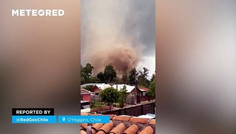
An impressive tornado causes significant property damage between Requínoa and Rengo, Chile