
Nepal faces devastating flooding: an earthquake, avalanche, natural dam and glacier are under investigation
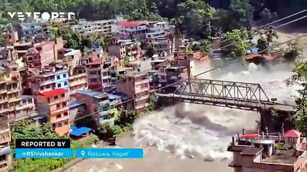
A sudden surge descended from the Himalayas with enormous destructive power. Scientists are investigating a possible chain of events that occurred near the border with Tibet.
A huge mass of water, mud, rocks and sediment swept down the narrow Himalayan valleys on Wednesday and violently struck a region close to the border between Nepal and Tibet. The torrent destroyed settlements, bridges, roads and hydroelectric facilities, while emergency teams launched a major search and rescue operation.
The Rasuwa district was one of the worst-affected areas following a flash flood that raced through mountain river channels. As the search for missing people continues, scientists are trying to answer a key question: what could have released such a huge volume of water and material in such a short time?
The surge is thought to have originated in the mountains of Tibet
Initial investigations have not yet established with certainty where the disaster began. While Chinese sources placed the origin of the flow on the Nepalese side, Nepalese authorities maintain that the flood may have descended from Tibet through the Bhote Koshi River, a discrepancy that has left the reconstruction of the event unresolved.
The death toll worsened as the hours passed. At least 98 people died in Nepal and China and hundreds remain missing, while Nepalese authorities are verifying a provisional list of 484 unaccounted-for travellers, most of them foreigners.
The hypothesis could explain why the disaster was initially described variously as a broken dam, an avalanche or the collapse of a glacier. In reality, all three elements may form part of the same chain of events, although the precise sequence of what happened at each stage still needs to be established.
A glacier collapsed more than 1,000 metres into the valley
One of the most important clues emerged from analysis of satellite imagery. According to Reuters, based on images from Planet Labs and assessments by specialists, a substantial section of a glacier located at around 5,200 metres above sea level broke away and fell more than 1,200 metres towards the valley.
Experts consulted by the agency **described the phenomenon as an ice-rock avalanche, an avalanche made up of ice, rock and other material. **Once it reached the valley floor, the enormous mass is thought to have blocked the river channel, creating a temporary accumulation before ultimately releasing an extremely sediment-laden flow.
When a barrier of this kind collapses, the danger comes from more than just the water. Mud, stones, boulders, ice and debris of all kinds greatly increase the destructive power of the flow, particularly in narrow valleys with steep slopes.
A horrific scene of severe flooding at the Rasuwagadhi border point on the Nepal-Tibet border.
— Ravi Pandey (@ravipandey2643) August 26, 2026
The strong currents wreaked havoc across the area, leaving 400 pilgrims and 105 Indian tourists also missing in the Nepal floods.#NepalFloods #Nepal #Rasuwa #FlashFlood #Floods pic.twitter.com/dwAX12Gj7l
The surge travelled through the Lhende and Bhote Koshi river systems before subsequently reaching the Trishuli. According to specialists cited by Reuters, at some locations the river level rose by as much as nine metres in around half an hour, an increase that left communities downstream with very little time to react.
Could an earthquake have triggered the chain of events?
Another element being investigated is an earthquake recorded in the Tibetan region before the flood. According to an update from the United States Geological Survey (USGS), the earthquake had a magnitude of 5.2, higher than preliminary estimates that had initially placed it at 4.4.
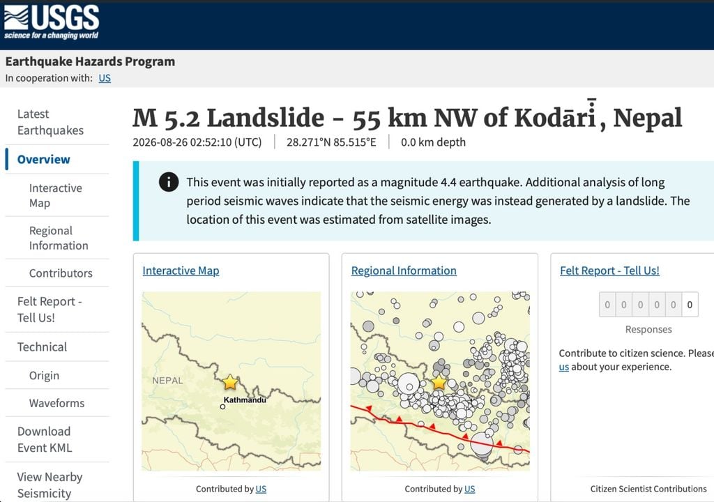
The temporal and geographical proximity to the area of the collapse has led specialists to consider whether the movement may have helped destabilise the mass of ice and rock. However, there is currently insufficient evidence to establish that the earthquake directly triggered the avalanche, so that relationship remains under investigation.
Nor can the possibility be ruled out that the impact of the collapse was powerful enough to generate a seismic movement. However, all of this remains the subject of analysis and investigation at present.
Roads, bridges and villages were swept away
The scale of the damage demonstrates the extraordinary energy acquired by the flow as it descended from the mountain. According to Nepal's Department of Roads, the flooding severely affected the corridor between Betrawati and the Rasuwagadhi border crossing, with numerous sections destroyed and several bridges swept away by the water.
This image helps explain what happened along the NepalTibet border. According to reports, a magnitude 4.4 earthquake on the Tibetan side triggered a massive ice avalanche, which then led to the flash flooding of the Bhotekoshi River in Nepal. Around 1,000 people are missing, and pic.twitter.com/2n46czGNoB
— Weather Monitor (@WeatherMonitors) August 26, 2026
Settlements located alongside the Bhote Koshi and other waterways were particularly exposed, while authorities extended alerts to areas further downstream. The disaster also struck hydroelectric projects and a strategic trade route between Nepal and China, according to official reports cited by local media.
A region increasingly exposed to glacial hazards
The disaster occurred in one of the world's most sensitive mountainous regions, where retreating glaciers are rapidly transforming the landscape. Scientific organisations specialising in the Himalayas, such as the International Centre for Integrated Mountain Development (ICIMOD), have been warning about increasing risks associated with glacial lakes, collapses and sudden floods in the region.
It is not yet possible to directly attribute this disaster to climate change, but experts warn that warming in the Himalayas could increase certain risks associated with high-altitude ice. Melting alters glaciers, expands lakes and can contribute to changes in the stability of slopes made up of ice, rock and sediment.
What happened in Rasuwa also demonstrates why these phenomena are so difficult to anticipate. A collapse occurring more than 5,000 metres above sea level can trigger a chain reaction and, just minutes later, become a devastating flood tens of kilometres downstream.