Observing the “Eye” of the Sahara from space
Also known as the Richat Structure, it is a large geological formation composed of concentric ridges located on the eastern side of a plateau in Mauritania.
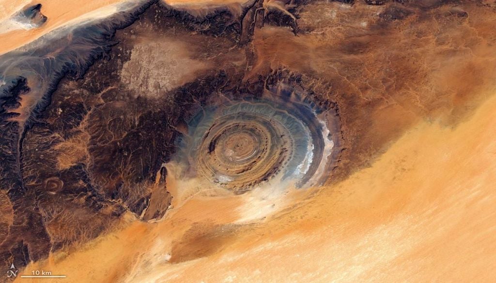
At the edge of a dark plateau flanked by desert sands, one can see a large concentric rock formation resembling a bullseye, displaying a range of colours.
The Richat Structure appears as a gigantic “target” on a Mauritanian plateau in this mosaic composed of images captured by the Operational Land Imager on Landsat 9 and Landsat 8 on 5 and 6 March 2026.
A uniquely shaped structure
In a remote region of northern Mauritania, on the Adrar Plateau, stretches a desert landscape rich in human history. This area of north-west Africa is dotted with Palaeolithic stone tools, Neolithic rock art and remains of medieval settlements once used by caravans crossing the Sahara Desert.
Seen from space, the landscape appears to be shaped mainly by natural forces. Wind has sculpted colourful sand dune seas and eroded plateaus covered with dark desert pavement, while ancient water flows carved valleys and networks of dry riverbeds.
But the most striking feature of the region, when viewed from above, is the Richat Structure itself, a large geological formation made up of concentric ridges on the eastern side of the plateau.
French geographers first described it in the 1930s, calling it the “Eye” of Richat. NASA astronauts Ed White and James McDivitt helped popularise it globally as the “Eye of the Sahara” after photographing it during their historic Gemini IV mission.
Initially, the 40-kilometre-wide structure was thought to be an impact crater, since large meteorites can create circular formations on Earth’s surface. However, researchers later demonstrated that it is actually a deeply eroded geological dome, formed by the uplift of rock above a subsurface intrusion of igneous material. Over time, different erosion rates among rock types in the exposed dome created circular ridges known as cuestas. The orange and grey colours reflect differences in sedimentary and igneous rock types across the structure and surrounding landscape.
Image from NASA Earth Observatory, produced by Lauren Dauphin using Landsat data from the United States Geological Survey. Article by Adam Voiland.
Source of the news: NASA