Why is the terrible 'Santa Ana wind' making it impossible to extinguish the fires in Los Angeles, California?
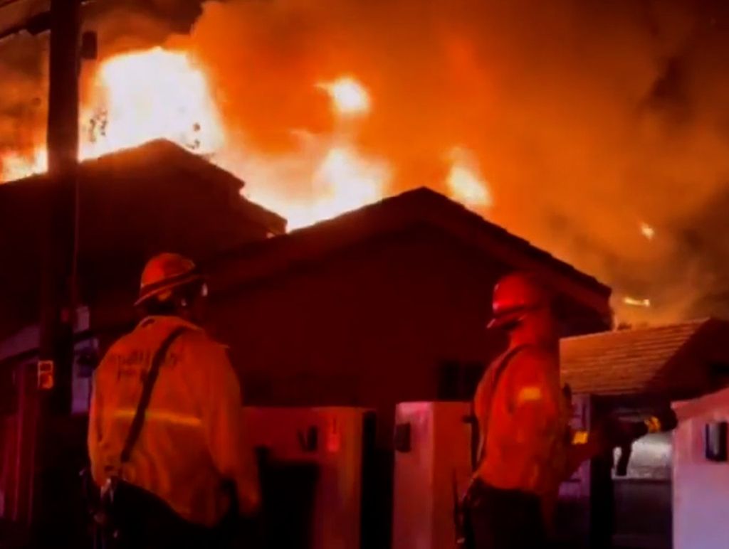
Los Angeles County is currently facing a series of devastating wildfires that are destroying entire settlements and causing fatalities, forcing local authorities to evacuate more than 100,000 people.
Los Angeles County is currently facing a series of devastating fires that are destroying entire neighborhoods and causing casualties, forcing local authorities to evacuate more than 100,000 people.
More than 1,400 firefighters were deployed to try to put out the flames. The fires affected the Palm Palisades district and Eaton Canyon, near the city of Altadena, the Sylmar district and the Tamarack area.
This already dramatic situation is aggravated by the hot, dry Santa Ana winds, which blow from the interior and from the Californian mountain ranges to the coastal strip, heating up and drying out the area during this process. In addition, it tends to accelerate in some valleys or ravines in the area.
How is the Santa Ana wind produced?
The Santa Ana winds are well known throughout Southern California, especially during the fall and winter seasons.
Santa Ana winds will restrengthen Thursday and last into Friday for inland areas. Slightly weaker than Wednesday for areas north of San Diego County. Slightly stronger than Wednesday for San Diego County. Critical fire weather conditions are expected! pic.twitter.com/7MdME6vsEn
NWS San Diego (@NWSSanDiego) January 8, 2025
However, significant episodes can also occur in spring and in the middle of the summer season, giving rise to unbearable heat waves that cause thermometers to soar above the 42-44 ºC threshold along the coastal strip, while in the areas of the nearby Californian interior temperatures can exceed the 45 ºC barrier.
Along the southernmost edge of this anticyclone, often located between the Mojave Desert or the Great Basin, a flow from the northeast is triggered, pushing air masses, normally of continental origin, which warm up as they approach the Californian coast.
Here, these currents or flows from the northeast are channeled into the main canyons that rush towards the Pacific coast.
Once channeled into these rather narrow and elongated canyons facing the Pacific Ocean, the Santa Ana winds, initially weak or at most moderate, begin to strengthen significantly, due to the orographic channeling.

Finally, they end up leaving at high speed, under impetuous gusts that fan out towards the coastal strip, where the wind, depending on the local orographic conformation, acquires a typical NE or E-NE component.
When can the Santa Ana become a violent wind?
If the subtropical anticyclone, located between the Mojave Desert and the Great Basin desert area in Nevada, has a significant barometric gradient along its southern edge, the "Santa Ana" can blow along the coast of southern California with very violent gusts, which can easily reach peaks of more than 100-120 km/h along the outlet of the main canyons.
The strongest wind gusts recorded over the Los Angeles area are associated with intense Santa Ana events. On the leeward slopes of the Southern California mountain ranges, downwelling winds can reach truly remarkable speeds, peaking at over 170-190 km/h.
To this we must add the already intense gradient wind, accompanied by orographic channelling and the marked downward component of the wind, which moves from the inland reliefs towards the coast, gaining considerable speed during the descent, with swirling and turbulent gusts.
It is no coincidence that the most violent gales that hit Southern California , and in particular the area of Los Angeles, Hollywood and the stretch of coast to San Diego, are almost always associated with intense episodes of "Santa Ana".
the wind in LA is INSANE rn pic.twitter.com/T5GU8z1FEh
— juju (@ayeejuju) January 9, 2025
In the most extreme cases, the most violent "Santa Ana" storms develop under conditions of strong barometric gradients in southern California, between a robust anticyclonic ridge that extends from Oregon to northern California, while a trough is often isolated over Arizona, near the Colorado Plateau.
Along the boundary between these action centers (anticyclones and depressions) the compression of the "horizontal baric gradient" is such that it gives rise to an intense northerly wind, which is channeled towards the canyons of southern California, to be reinforced in the Los Angeles area , where hurricane-force gusts can be recorded.
Santa Ana winds in winter
However, it should be noted that air masses from the Great Basin and Mojave Desert , especially in winter and spring, tend to be much colder than those from the coastal area of Southern California.
But above all, it is much denser and heavier. The intense "density gradient" between the colder air masses present over the Great Basin of Nevada and the warmer air masses in the lower layers along the coastal zone, tends to further accelerate these descending circulations, which become very turbulent, giving rise to very strong gusts , capable of reaching peaks of more than 70-80 km/h.

Under such conditions, which are common in the fall, coastal California locations experience temperatures much higher than those recorded in the inland deserts of California, Arizona and Nevada.
These days, high temperatures, exacerbated by the "adiabatic compression" of air masses moving towards the Pacific coast (atmospheric subsidence aggravated by the orography), have further dried out vegetation already severely affected by the very scarce rainfall of recent months , turning it into prime fuel for the spread of these fires that are burning the hillsides of southern California.